CITY OF PANAMA CITY – PLANNING BOARD PUBLIC HEARING NOTICE
A meeting before the Planning Board, which is the City of Panama City’s Local Planning Agency, will be held on Monday, July 10, 2023, at4:00 PM to consider all issues herein. This meeting will take place on the Lower Level in Room 010 at City Hall, 501 Harrison Avenue, Panama City, FL. In light of COVID-19, should you wish to comment in person on this proposal, please be aware that social distancing precautions will be taken during the meeting and access to the meeting room may be restricted to smaller groups at a time. Alternatively, you can submit comments prior to the hearing date to the Development Services Department’s Planning Division:
In accordance with the Americans with Disabilities Act and Section 286.26, Florida Statutes, persons with disabilities needing special accommodation to participate in this proceeding should contact the City’s Human Resources Department prior to the proceeding at telephone (850) 872-3014 for assistance; if hearing impaired, telephone (850) 872-3028 (TDD) for assistance.
REQUESTS:
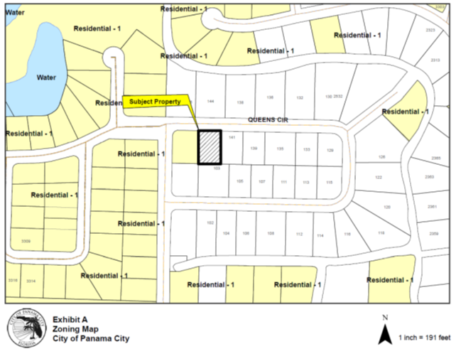
Case Number: CPMA2354 – Request for an annexation, land use change and rezoning of 0.34 acres (approx.) from Residential-1, R-1 (Bay County) to Residential-1, R-1 (Panama City) at 143 Queens Circle, Blake and Ashley E Watts Reese, owners and Blake Reese, applicant.
Zoning Map: The subject parcel, depicted by a black outline and black hatching, is located southeast of the Kings Road and Queens Circle intersection and west of Crown Court at 143 Queens Circle. The parcel adjacent to the subject property to the west is designated as Residential on the City’s Future Land Use Map and zoned Residential-1. The color indicated for R-1 zoning districts is yellow. Parcels to the North across Queens Circle, East, and to the South are designated as Residential on Bay County’s Future Land Use Map and zoned Residential-1. All parcels outside of the City of Panama City within Bay County are indicated by the color white.
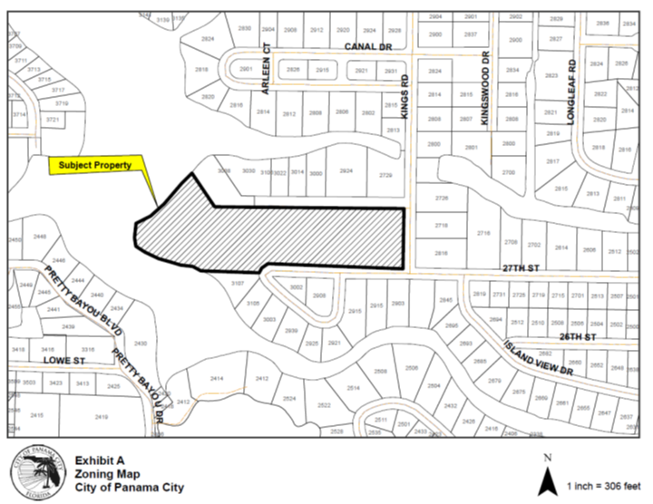
Case Number: CPMA2355 – Request for an annexation, land use change and rezoning of 8.16 acres (approx.) from Residential-1, R-1 (Bay County) to Residential-1, R-1 (Panama City) at 3106 W 27th Street, Daniel W. Davis II owner and applicant.
Zoning Map: The subject parcel, depicted by a black outline and black hatching, is located West of the intersection of Kings Road and W 27th Street at 3106 W 27th Street. The subject parcel and all neighboring parcels are designated as Residential on Bay County’s Future Land Use Map and zoned Residential-1. All parcels outside of the City of Panama City within Bay County are indicated by the color white.
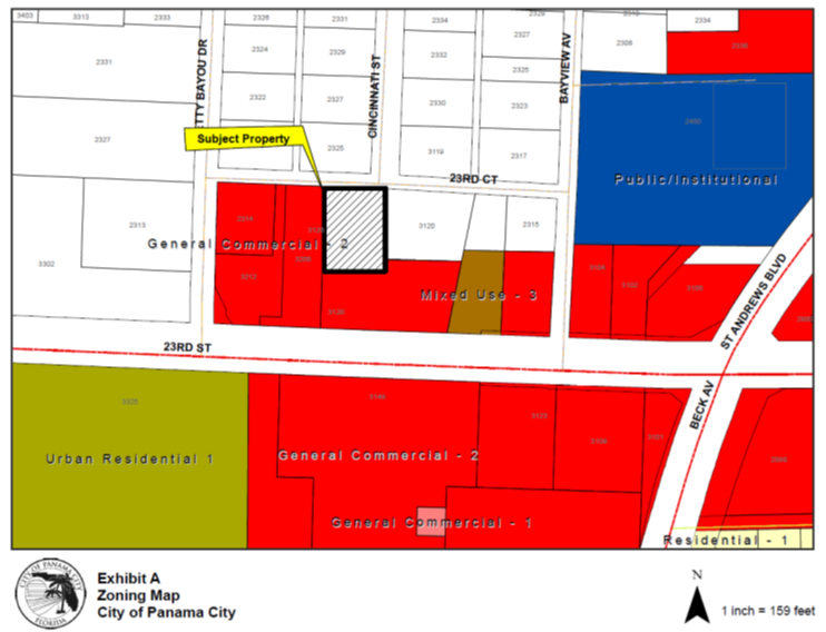
Case Number: CPMA2356– Request for an annexation, land use change and rezoning of 0.55 acres (approx.) from Residential-1, R-1 (Bay County) to General Commercial-2, GC-2 (Panama City) at 3128 W 23rd Court, Stoney Point Investments, LLC, owner and Michael K Weber, applicant.
Zoning Map: The zoning map depicts the subject property with black hatching and a black outline, located at 3128 W 23rd Court, located northwest of the W 23rd Street and Bayview Avenue intersection and northeast of W 23rd Street and Pretty Bayou Drive intersection and south of the W 23rd Court and Cincinnati Street intersection. The subject property is currently zoned Residential-1 (Bay County) and is depicted by the color white. General Commercial-2, GC-2 is located to the southeast, south, and west of the subject property, depicted in Red. A parcel zoned Mixed Use-3, MU-3 is indicated by the color brown and located to the southeast. A parcel zoned Public Institutional (PI) is indicated by the color blue and located to the northeast across Bayview Avenue. A parcel zoned Urban Residential-1, UR-1 is located across 23rd Street to the south and indicated by the color green.
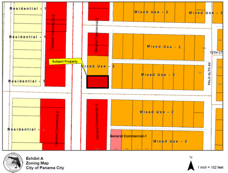
Case Number: CPMA2357– Request for a land use change and rezoning of 0.18 acres (approx.) from General Commercial-2, GC-2 (Panama City) to Mixed Use-2, MU-2 (Panama City) at 1200 Martin Luther King Jr. Boulevard, Farriel Lee Moore, owner and applicant.
Zoning Map: The zoning map depicts the subject property with black hatching and a black outline, located immediately northeast of the Martin Luther King Jr. Boulevard/ Highway 77 and E 12th Street intersection. The subject property is currently zoned General Commercial-2, GC-2 and is depicted by the color red. GC-2 is located to the south and west. Parcels zoned Mixed Use, MU-2 are located to the east. A parcel zoned General Commercial-1, GC-1 is located further south. Parcels zoned Residential-1, R-1 are also located across Martin Luther King Jr. Boulevard/ Highway 77 and depicted by the color yellow.