NOTICE IS HEREBY GIVEN that the City of Panama City, Florida, proposes to adopt the following ordinances. The City Commission will consider the ordinances at 8:00 A.M. on April 25, 2023, at Bay County Government Center Commission Chambers, 840 W 11th St, Panama City. Interested parties may appear at the meeting and be heard with respect to the proposed ordinances.
The public is invited to inspect and obtain a copy of the proposed ordinances and the complete legal description by metes and bounds at the Development Services Department, 501 Harrison Avenue, Room 217, Panama City, Florida, between the hours of 8:00 am to 5:00 pm, Monday through Friday.
A person who decides to appeal any decision made by any board, agency, or council with respect to any matter considered at such meeting or hearing will need a record of the proceedings. For such purposes, any such person may need to ensure that a verbatim record of the proceedings is made, which includes the testimony and evidence upon which the appeal is based.
Persons with disabilities needing assistance to participate in any of these proceedings should contact Jan Smith, City Clerk, at (850) 872-3020 at least 48 hours before the date of the scheduled hearing
The following ordinance (s) will be presented for a first reading:
ORDINANCE NO. 3147
AN ORDINANCE OF THE CITY COMMISSION OF THE CITY OF PANAMA CITY, FLORIDA, AMENDING THE CITY’S UNIFIED LAND DEVELOPMENT CODE, CHAPTER 105, “DESIGN STANDARDS”, SEC. 105-14, OUTDOOR DINING STANDARDS.
ORDINANCE NO. 3149
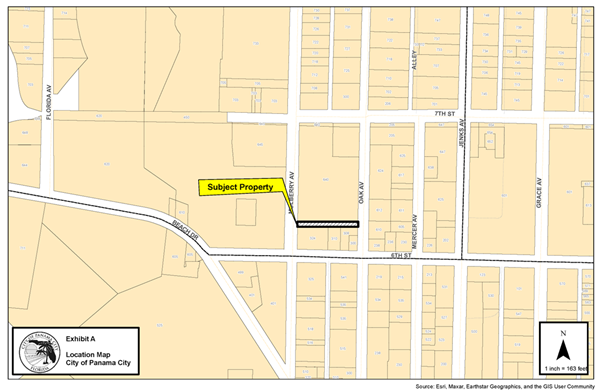
AN ORDINANCE VACATING AND ABANDONING PLATTED STREET RIGHT-OF-WAY LOCATED TO THE NORTHEAST OF MULBERRY AVENUE AND W 6TH SPRING AVENUE AND NORTHWEST OF THE OAK AVENUE AND EAST 6TH STREET INTERSECTIONS PANAMA CITY, FLORIDA, AS MORE PARTICULARLY HEREINAFTER DESCRIBED; REPEALING ALL ORDINANCES IN CONFLICT HEREWITH; PROVIDING FOR THE SEVERABILITY OF ANY PART OF THIS ORDINANCE DECLARED INVALID; AND PROVIDING FOR AN EFFECTIVE DATE.
The following ordinance(s) will be presented for a final reading:
ORDINANCE NO. 3144.1
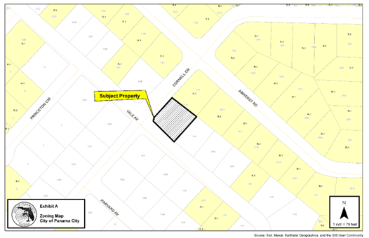
AN ORDINANCE OF THE CITY APPROVING THE VOLUNTARY ANNEXATION OF 0.330 ACRES OF UNINCORPORATED PROPERTY LOCATED AT 1114 YALE AVENUE, BAY COUNTY, FLORIDA, INTO THE CITY, AS FURTHER DEFINED HEREINAFTER, AMENDING THE WARDS AND BOUNDARIES OF THE CITY TO INCLUDE SAID LAND AND PROVIDING FOR AN EFFECTIVE DATE.
ORDINANCE NO. 3144.2
AN ORDINANCE AMENDING THE COMPREHENSIVE PLAN FUTURE LAND USE MAP OF THE CITY TO REFLECT A LAND USE DESIGNATION OF RESIDENTIAL FOR A PARCEL OF PROPERTY LOCATED AT 1114 YALE AVENUE, PANAMA CITY, FLORIDA, PROVIDING FOR A REPEALER, PROVIDING FOR SEVERABILITY, AND PROVIDING FOR AN EFFECTIVE DATE.
ORDINANCE NO. 3144.3
AN ORDINANCE ZONING A PARCEL OF PROPERTY LOCATED AT 1114 YALE AVENUE, PANAMA CITY, FLORIDA, HAVING APPROXIMATELY .330 ACRE, RESIDENTIAL LOW DENSITY-1, PROVIDING FOR SEVERABILITY AND PROVIDING FOR AN EFFECTIVE DATE.
ORDINANCE NO. 3145.1
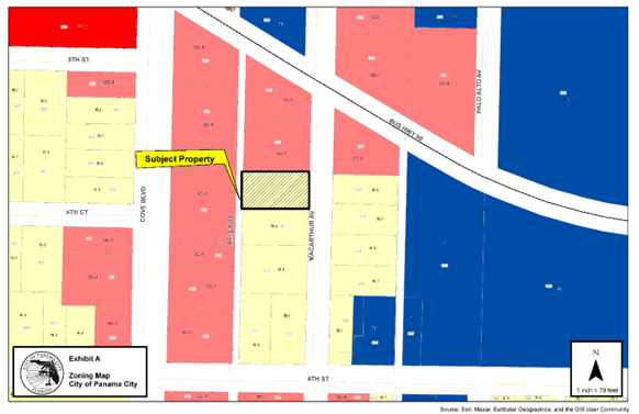
AN ORDINANCE AMENDING THE COMPREHENSIVE PLAN FUTURE LAND USE MAP OF THE CITY TO REFLECT A LAND USE DESIGNATION OF GENERAL COMMERCIAL FOR A PARCEL OF PROPERTY LOCATED AT 421 NORTH MACARTHUR, (PARCEL ID 20789-000-000), PANAMA CITY, FLORIDA, PROVIDING FOR A REPEALER, PROVIDING FOR SEVERABILITY, AND PROVIDING FOR AN EFFECTIVE DATE.
ORDINANCE NO. 3145.2
AN ORDINANCE ZONING A PARCEL OF PROPERTY LOCATED AT 421 NORTH MACARTHUR AVENUE, (PARCEL ID 20789-000-000), PANAMA CITY, FLORIDA, HAVING APPROXIMATELY 0.25 ACRES, GENERAL COMMERCIAL-1, GC-1, PROVIDING FOR SEVERABILITY AND PROVIDING FOR AN EFFECTIVE DATE.
ORDINANCE NO. 3146.1
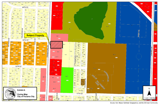
AN ORDINANCE AMENDING THE COMPREHENSIVE PLAN FUTURE LAND USE MAP OF THE CITY TO REFLECT A LAND USE DESIGNATION OF MIXED USE FOR A PARCEL OF PROPERTY LOCATED AT 1838 FRANKFORD AVENUE, (PARCEL ID 13838-000-000), PANAMA CITY, FLORIDA, PROVIDING FOR A REPEALER, PROVIDING FOR SEVERABILITY, AND PROVIDING FOR AN EFFECTIVE DATE.
ORDINANCE NO. 3146.2
AN ORDINANCE ZONING A PARCEL OF PROPERTY LOCATED AT 1838 FRANKFORD AVENUE, (PARCEL ID 13838-000-000), PANAMA CITY, FLORIDA, HAVING APPROXIMATELY 1.036 ACRES, MIXED USE-2, MU-2, PROVIDING FOR SEVERABILITY AND PROVIDING FOR AN EFFECTIVE DATE.