NOTICE IS HEREBY GIVEN that the City of Panama City, Florida, proposes to adopt the following ordinances. The City Commission will consider the ordinances at 8:00 A.M. on June 27, 2023 at Bay County Government Center Commission Chambers, 840 W 11th St, Panama City. Interested parties may appear at the meeting and be heard with respect to the proposed ordinances.
The public is invited to inspect and obtain a copy of the proposed ordinances and the complete legal description by metes and bounds at the Development Services Department, 501 Harrison Avenue, Room 217, Panama City, Florida, between the hours of 8:00 am to 5:00 pm, Monday through Friday.
A person who decides to appeal any decision made by any board, agency, or council with respect to any matter considered at such meeting or hearing will need a record of the proceedings. For such purposes, any such person may need to ensure that a verbatim record of the proceedings is made, which includes the testimony and evidence upon which the appeal is based.
Persons with disabilities needing assistance to participate in any of these proceedings should contact Jan Smith, City Clerk, at (850) 872-3020 at least 48 hours before the date of the scheduled hearing.
The following development agreement will be presented for a final reading and public hearing:
Case Number DEVA2353: The property owner(s), CSS ST. ANDREWS, LLC, has requested a Development Agreement. A copy of the proposed agreement can be obtained at the Development Services Department’s Planning Division, 2nd Floor, Room 217, 501 Harrison Avenue Panama City, Florida 32401.
Subject Property: BECK AVENUE (PARCEL ID # 29999-000-000), BECK AVENUE (PARCEL ID # 30000-000-000), 1219 BECK AVENUE (PARCEL ID# 29995-000-000), 1227 BECK AVENUE (PARCEL ID# 29998-000-000), 1213 BECK AVENUE (PARCEL ID# 29996-000-000), 1201 BECK AVENUE (PARCEL ID# 29997-000-000). See Map below.
Request: The development agreement seeks to maintain the current land development regulations as provided in the St. Andrews District (StAD) zoning regulations. The development agreement does not propose population densities. The density shall be no greater than 35 dwelling units per acre. No structure or any part thereof shall exceed a vertical height of 100 feet from the preconstruction ground elevation of the site, plus 25 feet for roof and mechanical, provided that the ground elevation is above the base flood elevation as determined by a Florida registered land surveyor. Where the site has various elevations, the height as structured shall be measured from the base flood elevation of the site or the averaged site elevation, whichever is greater. Where the block is across the street from a residential zoning district, the vertical height along the side of the new development shall be limited to 40 feet. Any building constructed on the first 100 feet of the Property that is adjacent to Beck Ave shall be limited to the maximum height of 4 stories (each story not to exceed 12 feet, except commercial where the first floor may be 25 feet).
The permitted uses within the zoning district are as follows unless prohibited in Sec. 104-34 (C) in the ULDC.
- Civic uses such as meeting halls, libraries, post offices, schools, clubhouses, religious buildings, recreational facilities, higher education, museums, cultural societies, visual and performance arts buildings, municipal buildings, and substantially similar uses.
- Professional office uses such as accountants, architects, attorneys, engineers, doctors, dentists, insurance sales, realtors, technology companies, and the like.
- Open air retail such as farmers’ markets, and temporary seasonal produce stands.
- Hotels, inns, and bed and breakfasts.
- Artisan production establishment including wood working shops.
- Restaurants (no drive-thru) including sidewalk cafes, dinner clubs, lounges and coffee shops.
- Bars, breweries, microbreweries, taprooms, taverns, pubs, and sports clubs.
- Specialty retail uses such as bait and tackle shops, garden supply shops, and dress shops.
- Dance and martial arts studios or schools and fine arts centers, theaters and auditoriums.
- Specialty food stores such as meat markets, delicatessens and bakeries.
- Commercial marinas, private and public.
- Parking garages and parking lots.
- Passive recreational establishments with activities such as picnicking, jogging, cycling, and hiking.
- Technology and support services.
- Residential uses including single and multi-family.
Sec. 104-34 (C) – Additional requirements:
1. Any existing business, as of the date of this district, that is redeveloped or improved by more than 50 percent of its value shall go before the planning board for approval. Approval shall be required if the business is not currently permitted under the district’s allowable uses. The proposed building shall be required to meet current code.
2. Confine ground and building lighting to the property without causing direct light to protrude on adjacent properties.
3. Credit shall be applied for existing impervious surface; provided the new development is built over the existing impervious surface. However, new development exceeding these areas or building in a different location on the property will be subject to the city’s stormwater requirements.
4. Restrict residential dwelling units from occurring on the ground floor of any development directly facing or located on Beck Avenue. The ground floor shall be devoted exclusively to commercial, retail or office uses.
5. Maintain and promote the historic architectural character through the scale and massing of buildings. New construction shall utilize historic design elements that are complimentary to the neighborhood character. Renovations to existing buildings shall retain historic elements and/or add historic elements in keeping with the historic look and character of the area.
6. Provide off-street parking as specified in chapter 108.
7. At least 75 percent of all visible walls and roofs shall be made of wood, brick, non-mirrored glass, terracotta, stucco over masonry, textured concrete block, roof tiles or shingles, architectural concrete panels, or noncorrosive standing-seam metal roof or similar materials.
The following ordinance(s) will be presented for a second and final reading and public hearing:
ORDINANCE NO. 3157.1
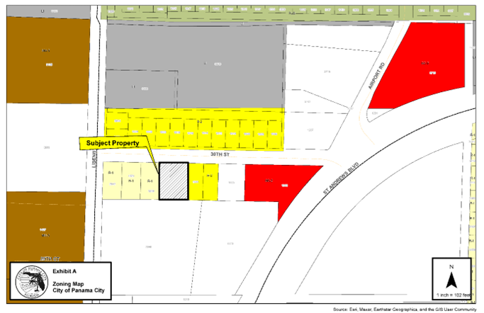
AN ORDINANCE OF THE CITY APPROVING THE VOLUNTARY ANNEXATION OF 0.303 ACRES OF UNINCORPORATED PROPERTY LOCATED AT 1313 W 30TH STREET, (PARCEL ID 13055-000-000), INTO THE CITY, AS FURTHER DEFINED HEREINAFTER, AMENDING THE WARDS AND BOUNDARIES OF THE CITY TO INCLUDE SAID LAND AND PROVIDING FOR AN EFFECTIVE DATE.
ORDINANCE NO. 3157.2
AN ORDINANCE AMENDING THE COMPREHENSIVE PLAN FUTURE LAND USE MAP OF THE CITY TO REFLECT A LAND USE DESIGNATION OF RESIDENTIAL FOR A PARCEL OF PROPERTY LOCATED AT 1313 W 30TH STREET, (PARCEL ID 13055-000-000), PANAMA CITY, FLORIDA, PROVIDING FOR A REPEALER, PROVIDING FOR SEVERABILITY, AND PROVIDING FOR AN EFFECTIVE DATE.
ORDINANCE NO. 3157.3
AN ORDINANCE ZONING A PARCEL OF PROPERTY LOCATED AT 1313 W 30TH STREET, (PARCEL ID 13055-000-000), PANAMA CITY, FLORIDA, HAVING APPROXIMATELY 0.303 ACRES, RESIDNETIAL-2 R-2, PROVIDING FOR SEVERABILITY AND PROVIDING FOR AN EFFECTIVE DATE.
ORDINANCE NO. 3158.1
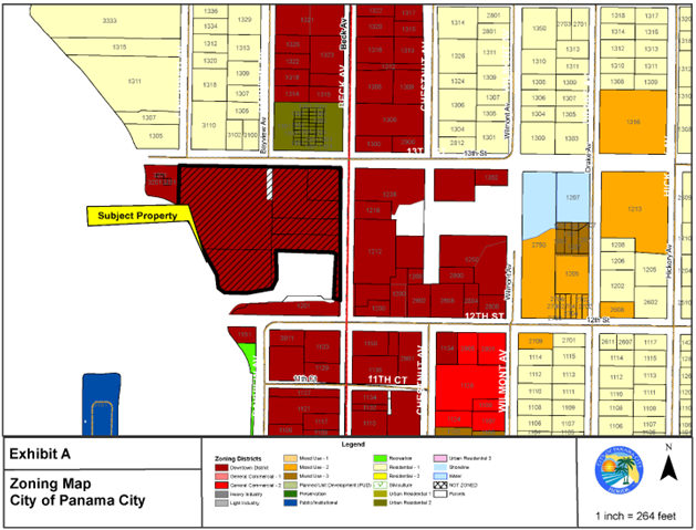
AN ORDINANCE AMENDING THE COMPREHENSIVE PLAN FUTURE LAND USE MAP OF THE CITY TO REFLECT A LAND USE DESIGNATION OF MIXED USE FOR A PARCEL OF PROPERTY LOCATED AT 1413 FRANKFORD AVENUE, (PARCEL ID 29640-000-000), PANAMA CITY, FLORIDA, PROVIDING FOR A REPEALER, PROVIDING FOR SEVERABILITY, AND PROVIDING FOR AN EFFECTIVE DATE.
ORDINANCE NO. 3158.2
AN ORDINANCE ZONING A PARCEL OF PROPERTY LOCATED AT 1413 FRANKFORD AVENUE, (PARCEL ID 29640-000-000), PANAMA CITY, FLORIDA, HAVING APPROXIMATELY 0.409 ACRES, GENERAL COMMERICAL-2, GC-2, PROVIDING FOR SEVERABILITY AND PROVIDING FOR AN EFFECTIVE DATE.
ORDINANCE NO. 3159.1
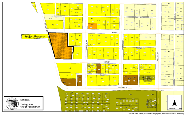
AN ORDINANCE AMENDING THE COMPREHENSIVE PLAN FUTURE LAND USE MAP OF THE CITY TO REFLECT A LAND USE DESIGNATION OF MIXED USE FOR A PARCEL OF PROPERTY LOCATED 621 E BEACH DRIVE, PANAMA CITY, FLORIDA, PROVIDING FOR A REPEALER, PROVIDING FOR SEVERABILITY, AND PROVIDING FOR AN EFFECTIVE DATE.
ORDINANCE NO. 3159.2
AN ORDINANCE ZONING A PARCEL OF PROPERTY LOCATED AT 621 E BEACH DRIVE, (PARCEL ID 20307-000-000), PANAMA CITY, FLORIDA, HAVING APPROXIMATELY 1.423 ACRES, RESIDENTIAL-1, R-1, PROVIDING FOR SEVERABILITY AND PROVIDING FOR AN EFFECTIVE DATE.