Notice of Public Hearing
NOTICE IS HEREBY GIVEN that the City of Panama City, Florida, proposes to adopt the following ordinances. The City Commission will consider the ordinances at 8:00 A.M. on June 13, 2023, at Bay County Government Center Commission Chambers, 840 W 11th St, Panama City. Interested parties may appear at the meeting and be heard with respect to the proposed ordinances.
The public is invited to inspect and obtain a copy of the proposed ordinances and the complete legal description by metes and bounds at the Development Services Department, 501 Harrison Avenue, Room 217, Panama City, Florida, between the hours of 8:00 am to 5:00 pm, Monday through Friday.
A person who decides to appeal any decision made by any board, agency, or council with respect to any matter considered at such meeting or hearing will need a record of the proceedings. For such purposes, any such person may need to ensure that a verbatim record of the proceedings is made, which includes the testimony and evidence upon which the appeal is based.
Persons with disabilities needing assistance to participate in any of these proceedings should contact Jan Smith, City Clerk, at (850) 872-3020 at least 48 hours before the date of the scheduled hearing.
The following ordinance(s) will be presented for a first reading:
ORDINANCE NO. 3157.1
AN ORDINANCE OF THE CITY APPROVING THE VOLUNTARY ANNEXATION OF 1.12 ACRES OF UNINCORPORATED PROPERTY LOCATED AT 1313 W 30TH STREET, (PARCEL ID 13055-000-000), INTO THE CITY, AS FURTHER DEFINED HEREINAFTER, AMENDING THE WARDS AND BOUNDARIES OF THE CITY TO INCLUDE SAID LAND AND PROVIDING FOR AN EFFECTIVE DATE.
ORDINANCE NO. 3157.2
AN ORDINANCE AMENDING THE COMPREHENSIVE PLAN FUTURE LAND USE MAP OF THE CITY TO REFLECT A LAND USE DESIGNATION OF RESIDENTIAL FOR A PARCEL OF PROPERTY LOCATED AT 1313 W 30TH STREET, (PARCEL ID 13055-000-000), PANAMA CITY, FLORIDA, PROVIDING FOR A REPEALER, PROVIDING FOR SEVERABILITY, AND PROVIDING FOR AN EFFECTIVE DATE.
ORDINANCE NO. 3157.3
AN ORDINANCE ZONING A PARCEL OF PROPERTY LOCATED AT 1313 W 30TH STREET, (PARCEL ID 13055-000-000), PANAMA CITY, FLORIDA, HAVING APPROXIMATELY 0.303 ACRES, RESIDNETIAL-2 R-2, PROVIDING FOR SEVERABILITY AND PROVIDING FOR AN EFFECTIVE DATE.
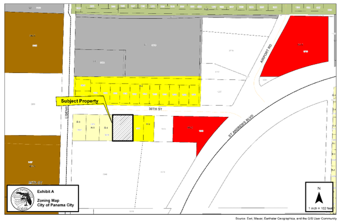
Zoning Map: The zoning map depicts the subject parcel, depicted by black hatching and a black outline, located at 1313 W 30th Street, immediately south of W 30th Street. Parcels within Bay County are depicted in the color white. The parcel is currently located within western Bay County. Parcels located within the City of Panama City zoned Residential-1, R-1 depicted by are located to the west depicted by a light-yellow color and parcels zoned Residential-2, R-2 are located to the east depicted by the color yellow. Parcels zoned R-2 are located to the north across W 30th Street. Parcels zoned Light Industrial, depicted by the color grey are located further north and located within the City of Panama City. Parcels located immediately to the south are located within Bay County. Parcels to the east across Lisenby Avenue are located within the City of Panama City and zoned Mixed Use-3, MU-3, depicted by the color brown. Parcels located within the City of Panama City are also located to the east and northeast and zoned General Commercial-2, GC-2 depicted by the color red.
ORDINANCE NO. 3158.1
AN ORDINANCE AMENDING THE COMPREHENSIVE PLAN FUTURE LAND USE MAP OF THE CITY TO REFLECT A LAND USE DESIGNATION OF GENERAL COMMERCIAL FOR A PARCEL OF PROPERTY LOCATED AT 1413 FRANKFORD AVENUE, (PARCEL ID 29640-000-000), PANAMA CITY, FLORIDA, PROVIDING FOR A REPEALER, PROVIDING FOR SEVERABILITY, AND PROVIDING FOR AN EFFECTIVE DATE.
ORDINANCE NO. 3158.2
AN ORDINANCE ZONING A PARCEL OF PROPERTY LOCATED AT 1413 FRANKFORD AVENUE, (PARCEL ID 29640-000-000), PANAMA CITY, FLORIDA, HAVING APPROXIMATELY 0.409 ACRES, GENERAL COMMERICAL-2, GC-2, PROVIDING FOR SEVERABILITY AND PROVIDING FOR AN EFFECTIVE DATE.
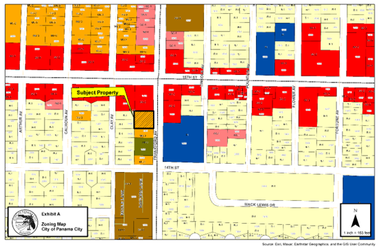
Zoning Map: The subject parcel, depicted by black hatching and a black outline, is located at 1413 Frankford Avenue in southwestern Panama City, southwest of the 15th Street and Frankford Avenue intersection and immediately west of Frankford Avenue. The subject parcel is zoned Mixed Use-2, MU-2, depicted by the color orange. Parcels located to the north and northwest are zoned General Commercial-2, GC-2, depicted by the color red. GC-2 is located to the northeast across Frankford. A parcel zoned Public institutional (P/I), depicted by the color blue is located to the southeast across Frankford Avenue. Parcels zoned MU-2 and Urban Residential-2, UR-2, depicted by the color green is located to the south. Residential-1, R-1 zoned parcel, depicted by the color yellow are located to the west.
ORDINANCE NO. 3159.1
AN ORDINANCE AMENDING THE COMPREHENSIVE PLAN FUTURE LAND USE MAP OF THE CITY TO REFLECT A LAND USE DESIGNATION OF RESIDENTIAL FOR A PARCEL OF PROPERTY LOCATED 621 E BEACH DRIVE, PANAMA CITY, FLORIDA, PROVIDING FOR A REPEALER, PROVIDING FOR SEVERABILITY, AND PROVIDING FOR AN EFFECTIVE DATE.
ORDINANCE NO. 3159.2
AN ORDINANCE ZONING A PARCEL OF PROPERTY LOCATED AT 621 E BEACH DRIVE, (PARCEL ID 20307-000-000), PANAMA CITY, FLORIDA, HAVING APPROXIMATELY 1.423 ACRES, RESIDENTIAL-1, R-1, PROVIDING FOR SEVERABILITY AND PROVIDING FOR AN EFFECTIVE DATE
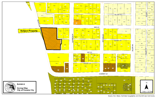
Zoning Map: The subject property, depicted by black hatching and a black outline, is located at 621 E Beach Drive in southern Panama City and zoned Mixed Use-2, MU-2, depicted in the color orange located southwest of the 2nd Street and Harmon Avenue intersection and east of Beach Drive. Parcels to the north, east and south of the subject property are predominately zoned Residential-2, R-2, depicted by the color yellow. One parcel north of 2nd Street is zoned Residential-1, R-1 depicted by the color light yellow. One parcel zoned MU-2 located to northeast of the Harmon Avenue and 2nd Street intersection is zoned MU-2. Parcel located to the south of 1st Court are predominately zoned R-2 and some are zoned Mixed Use-3, MU-3, depicted by the color brown. Parcels further to east are zoned Residential-1, R-1. Parcel located further to the south are zoned Urban Residential-1, UR-1 and depicted by the color green.