City of Panama City – Planning Board Public Hearing Notice
A meeting before the Planning Board, which is the City of Panama City’s Local Planning Agency, will be held on Monday, May 8, 2023, at4:00 PM to consider all issues herein. This meeting will take place on the Lower Level in Room 010 at City Hall, 501 Harrison Avenue, Panama City, FL. In light of COVID-19, should you wish to comment in person on this proposal, please be aware that social distancing precautions will be taken during the meeting and access to the meeting room may be restricted to smaller groups at a time. Alternatively, you can submit comments prior to the hearing date to the Development Services Department’s Planning Division:
Mail: Planning Division OR Phone: 850-691-4595
Development Services Department Email: planning@panamacity.gov
City of Panama City Hall
501 Harrison Avenue Panama City, FL 32401
Requests:
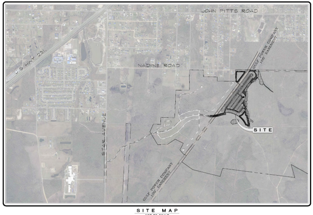
Case Number FIPL2346 – Approval of the Liberty Phase 3 Final Plat. D.R. Horton, owner and applicant.
Location Map: The map depicts the subject property and proposed plat located within the Liberty Planned Unit Development (PUD) in the northern portion of the City of Panama City, on the eastern side of Star Avenue, 5900 Star Avenue.
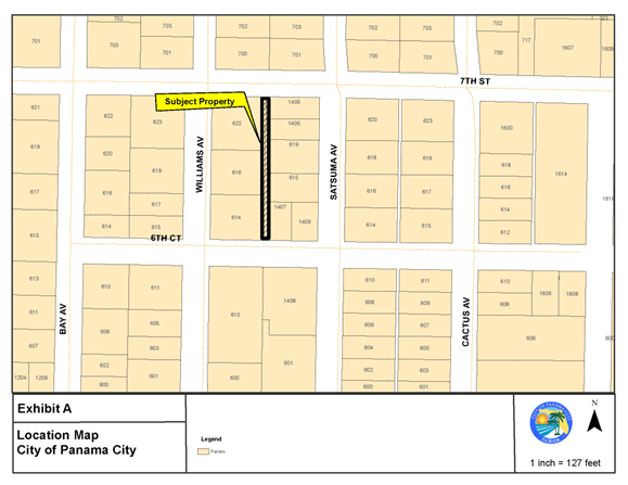
Case Number VROW2347 – The applicant requests the City to vacate the 20’ alleyway located immediately northeast of the Williams Avenue and E 6th Court intersection and south of E 7th Street. Edward Coley Morris is the applicant.
Location Map: The subject property, depicted by black hatching and a black outline, an approximately 20 ft. wide alleyway located immediately northeast of the Williams Avenue and E 6th Court intersection and south of E 7th Street. The alleyway is surrounded by beige colored parcels outlined in black. The general area is located within the southern portion of the City of Panama City.
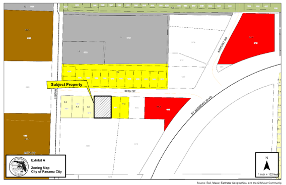
Case Number: VROW2348 – Request for annexation, land use change and rezoning of 0.303 acres (approx.) from Residential-1, R-1 (Bay County) to Residential-2, R-2 (Panama City) at 1313 W 30th Street. Samual Joseph Wirrick, owner and applicant.
Zoning Map: The zoning map depicts the subject parcel, depicted by black hatching and a black outline, located at 1313 W 30th Street, immediately south of W 30th Street. Parcels within Bay County are depicted in the color white. The parcel is currently located within western Bay County. Parcels located within the City of Panama City zoned Residential-1, R-1 depicted by are located to the west depicted by a light-yellow color and parcels zoned Residential-2, R-2 are located to the east depicted by the color yellow. Parcels zoned R-2 are located to the north across W 30th Street. Parcels zoned Light Industrial, depicted by the color grey are located further north and located within the City of Panama City. Parcels located immediately to the south are located within Bay County. Parcels to the east across Lisenby Avenue are located within the City of Panama City and zoned Mixed Use-3, MU-3, depicted by the color brown. Parcels located within the City of Panama City are also located to the east and northeast and zoned General Commercial-2, GC-2 depicted by the color red.
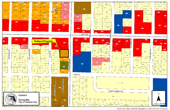
Case Number: CPMA2349 – Request for land use change and rezoning of 0.41 acres (approx.) from Mixed Use-2, MU-2 (Panama City) to General Commercial-2, GC-2 (Panama City) at 1413 Frankford Avenue, Pareshkumar C. Patel, owner and Brad Harris, P.E., BH Engineering, applicant.
Zoning Map: The subject parcel, depicted by black hatching and a black outline, is located at 1413 Frankford Avenue in southwestern Panama City, southwest of the 15th Street and Frankford Avenue intersection and immediately west of Frankford Avenue. The subject parcel is zoned Mixed Use-2, MU-2, depicted by the color orange. Parcels located to the north and northwest are zoned General Commercial-2, GC-2, depicted by the color red. GC-2 is located to the northeast across Frankford. A parcel zoned Public institutional (P/I), depicted by the color blue is located to the southeast across Frankford Avenue. Parcels zoned MU-2 and Urban Residential-2, UR-2, depicted by the color green is located to the south. Residential-1, R-1 zoned parcel, depicted by the color yellow are located to the west.
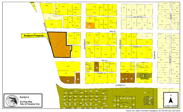
Case Number: CPMA2350 – Request for a rezoning of 1.42 acres (approx.) from Mixed Use-2, MU-2 (Panama City) to Residential-1, R-1 (Panama City) at 621 E Beach Drive, Richard and Kimberley Dodd, owners and Richard Dodd, applicant.
Zoning Map: The subject property, depicted by black hatching and a black outline, is located at 621 E Beach Drive in southern Panama City and zoned Mixed Use-2, MU-2, depicted in the color orange located southwest of the 2nd Street and Harmon Avenue intersection and east of Beach Drive. Parcels to the north, east and south of the subject property are predominately zoned Residential-2, R-2, depicted by the color yellow. One parcel north of 2nd Street is zoned Residential-1, R-1 depicted by the color light yellow. One parcel zoned MU-2 located to northeast of the Harmon Avenue and 2nd Street intersection is zoned MU-2. Parcel located to the south of 1st Court are predominately zoned R-2 and some are zoned Mixed Use-3, MU-3, depicted by the color brown. Parcels further to east are zoned Residential-1, R-1. Parcel located further to the south are zoned Urban Residential-1, UR-1 and depicted by the color green.
In accordance with the Americans with Disabilities Act and Section 286.26, Florida Statutes, persons with disabilities needing special accommodation to participate in this proceeding should contact the City’s Human Resources Department prior to the proceeding at telephone (850) 872-3014 for assistance; if hearing impaired, telephone (850) 872-3028 (TDD) for assistance.